Marine navigator - Fish finder - Boat GPS
Home
Power IR - Universal Remote Control
Marine Navigator
Web Controller
Android tutorial
Arduino tutorial
Java2ME and cellphones
Electronics projects
Renewable energy
Download page
Resources
Photos/Videos
Donate
Contact
Build Desktop PC
Android IR devices.
Power IR - Universal Remote Control
Marine Navigator - Fish Finder - Boat GPS.
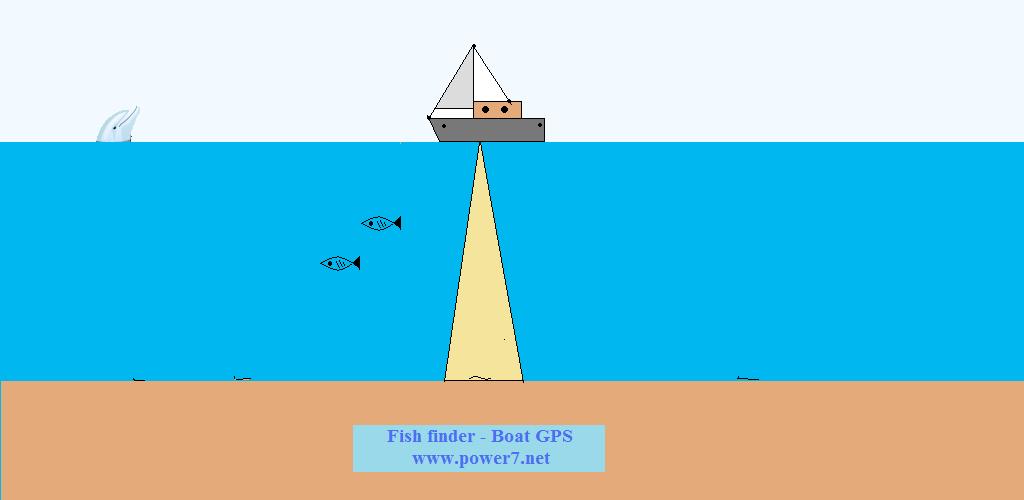 Marine Navigator , Fish finder and Boat GPS is an application for boats, cruisers, yachts, fishermen, captains to find the location, the speed, the direction,
the sea depth and helps you to save your fish area location, the mooring or another point.
Also it shows the distance between saved point and current location.
Another user from home or another boat can find your location (user choice) from a web browser or with call, reply sms.
When administrator user calls your android smartphone,it replies your location or from web browser via web server looks live location data from your smartphone.
Also this application is suitable for climpers,explorers,hunters....because it shows the elevation.
To shows the elevation or sea depth it use Google Geocoding API.It needs internet connection to work,
to download some bytes data with very small cost from mobile network.If you will use maps the data is more...some Kbytes.
If you are in a long range area,far from mobile cellphones networks you can connect your android with Iridium axcesspoint wifi hotspot for establish connection
from anywhere on Earth with a view of the sky with my or your web server.
Also added a map to shows your position in real time.Also you will can plot simple routes.
Added Alarm Elevation or Sea depth, for example when depth is higher > - 10 m the alarm fire or when depth is
lower < -200m.Alarm depth zone setup from user.It needs internet connection to work!!!
The accuracy is not the same such as a real depth meter near the land.
New function: Added 1.Geofense alarm.
When lat > y1 or lat < y2 or lon > x1 or lon < x2 the alarm fire...
For not alarm fire setup the default values lat +180-180, lon +90-90.
This function works without internet!!!
2.Location Name infos.
3.Marine Weather infos (Needs internet) .
User can choice if want to upload data to web server.
It works as a VHF channel for communication between users over internet.
I changed the file to upload data for this application to http://www.superir.net/marineloc.php
If you want to see the last upload data visit this link Internet VHF Channel Marine users .
I added and another http://www.superir.net/marineloc1.php and you can see the upload data to http://www.superir.net/marineloc1.txt
Also I added and marineloc2.php
I created for you a private database, table for upload locations, vessel calendar, vessel tracker with username,password.
Register account easy with username,password to register page in this web site.
You can access your data after register from Login page.
Send me e-mail if you are interested for premium account or details.
The user is responsible for proper use of the application for Personal Data Protection.
I suggest you to use the encryption if you select to upload data to webserver.
Receiver user can use decryption to find tracker location.
Please write small messages to upload to message box!!!
You can erase web server data with erase server button from setup menu.
In the next version i will add Radar function to show the on line Marine Navigator - Fish Finder users in real time with a radius of 50 Nautical miles!!!
I will add also function to receive data via AIS to avoid collisions with other ships.
Click on the map to look the marine traffic.I suggest to use Dolphin browser from android mobile device.
Usage Limits: Use of the Google Geocoding API is subject to a query limit of 2,500 geolocation requests per day. (User of Google Maps API Premier may perform up to 100,000 requests per day.) This limit is enforced to prevent abuse and/or repurposing of the Geocoding API, and this limit may be changed in the future without notice. Additionally, we enforce a request rate limit to prevent abuse of the service. If you exceed the 24-hour limit or otherwise abuse the service, the Geocoding API may stop working for you temporarily. If you continue to exceed this limit, your access to the Geocoding API may be blocked. Note: the Geocoding API may only be used in conjunction with a Google map; geocoding results without displaying them on a map is prohibited. For complete details on allowed usage, consult the Maps API Terms of Service License Restrictions.
Read and GPS Tracker upper because is similar application.
Stay online and update my site because is a new project and i am trying to enrich it with new functions so as to improve it.
Update also your application with new version from Google market.
If you do not like the advertisment send me e-mail to send you the application without ads and more functions.
If you like my work and my application, i could use your help in supporting the application and my attempt.
Simply click on the Donate button below to go to a secure PayPal donation page. Thanks for visiting.
Marine Navigator , Fish finder and Boat GPS is an application for boats, cruisers, yachts, fishermen, captains to find the location, the speed, the direction,
the sea depth and helps you to save your fish area location, the mooring or another point.
Also it shows the distance between saved point and current location.
Another user from home or another boat can find your location (user choice) from a web browser or with call, reply sms.
When administrator user calls your android smartphone,it replies your location or from web browser via web server looks live location data from your smartphone.
Also this application is suitable for climpers,explorers,hunters....because it shows the elevation.
To shows the elevation or sea depth it use Google Geocoding API.It needs internet connection to work,
to download some bytes data with very small cost from mobile network.If you will use maps the data is more...some Kbytes.
If you are in a long range area,far from mobile cellphones networks you can connect your android with Iridium axcesspoint wifi hotspot for establish connection
from anywhere on Earth with a view of the sky with my or your web server.
Also added a map to shows your position in real time.Also you will can plot simple routes.
Added Alarm Elevation or Sea depth, for example when depth is higher > - 10 m the alarm fire or when depth is
lower < -200m.Alarm depth zone setup from user.It needs internet connection to work!!!
The accuracy is not the same such as a real depth meter near the land.
New function: Added 1.Geofense alarm.
When lat > y1 or lat < y2 or lon > x1 or lon < x2 the alarm fire...
For not alarm fire setup the default values lat +180-180, lon +90-90.
This function works without internet!!!
2.Location Name infos.
3.Marine Weather infos (Needs internet) .
User can choice if want to upload data to web server.
It works as a VHF channel for communication between users over internet.
I changed the file to upload data for this application to http://www.superir.net/marineloc.php
If you want to see the last upload data visit this link Internet VHF Channel Marine users .
I added and another http://www.superir.net/marineloc1.php and you can see the upload data to http://www.superir.net/marineloc1.txt
Also I added and marineloc2.php
I created for you a private database, table for upload locations, vessel calendar, vessel tracker with username,password.
Register account easy with username,password to register page in this web site.
You can access your data after register from Login page.
Send me e-mail if you are interested for premium account or details.
The user is responsible for proper use of the application for Personal Data Protection.
I suggest you to use the encryption if you select to upload data to webserver.
Receiver user can use decryption to find tracker location.
Please write small messages to upload to message box!!!
You can erase web server data with erase server button from setup menu.
In the next version i will add Radar function to show the on line Marine Navigator - Fish Finder users in real time with a radius of 50 Nautical miles!!!
I will add also function to receive data via AIS to avoid collisions with other ships.
Click on the map to look the marine traffic.I suggest to use Dolphin browser from android mobile device.
Usage Limits: Use of the Google Geocoding API is subject to a query limit of 2,500 geolocation requests per day. (User of Google Maps API Premier may perform up to 100,000 requests per day.) This limit is enforced to prevent abuse and/or repurposing of the Geocoding API, and this limit may be changed in the future without notice. Additionally, we enforce a request rate limit to prevent abuse of the service. If you exceed the 24-hour limit or otherwise abuse the service, the Geocoding API may stop working for you temporarily. If you continue to exceed this limit, your access to the Geocoding API may be blocked. Note: the Geocoding API may only be used in conjunction with a Google map; geocoding results without displaying them on a map is prohibited. For complete details on allowed usage, consult the Maps API Terms of Service License Restrictions.
Read and GPS Tracker upper because is similar application.
Stay online and update my site because is a new project and i am trying to enrich it with new functions so as to improve it.
Update also your application with new version from Google market.
If you do not like the advertisment send me e-mail to send you the application without ads and more functions.
If you like my work and my application, i could use your help in supporting the application and my attempt.
Simply click on the Donate button below to go to a secure PayPal donation page. Thanks for visiting.
You can download it from Super IR Net Apps.
Also I created and another version for tablets....
You can download it from Google Play Android Market.
Power GPS Tracker.
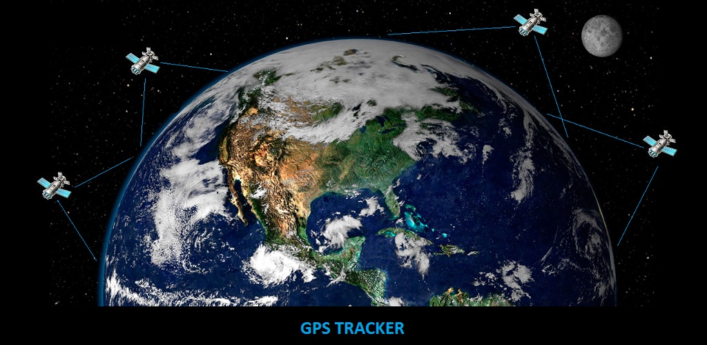 Satellite GPS Tracker Finder is an application for real time tracking.
Find the location of your car,boat,bike,friend,child,pet,arduino project....
You can upload the location data to my web server or with make a call and it reply with sms the location (setup administrator number for call+reply sms needed),enable GPS provider or use the default network provider,set the update time (secs) to listen location.When the application starts, shows Latitude,Longitude,Altitude,Accuracy,Speed,Direction,Battery level,temperature at real time with the refresh rate you have chosen.
Supports add encrypted number to show encrypted location.
When you exit from application you could erase the uploaded data from web server with erase button.
You can upload data to mine web server if you insert username and register account.
You can access your data from login page or you can see your last location data from Internet VHF Channel Land users
if you click the Enable publish checkbox.
If you don't like the ads,send me e-mail to send you the apk without ads.
You can find your lost phone!!!if administrator number call your android, it reply location,speed,battery informations with sms back to administrator number!!!
Added a new function to find a save point for example your car parking and it shows the distance between save point and your current location.
You can add an old android smartphone on your airplane,helicopter,multicopter,weather balloon to use it as flight tracker.
CAUTION:You may be charged with fees if you use the mobile network.
Increase the period time to upload data for lower fees.
You can download it from Google Play Android Market.
Satellite GPS Tracker Finder is an application for real time tracking.
Find the location of your car,boat,bike,friend,child,pet,arduino project....
You can upload the location data to my web server or with make a call and it reply with sms the location (setup administrator number for call+reply sms needed),enable GPS provider or use the default network provider,set the update time (secs) to listen location.When the application starts, shows Latitude,Longitude,Altitude,Accuracy,Speed,Direction,Battery level,temperature at real time with the refresh rate you have chosen.
Supports add encrypted number to show encrypted location.
When you exit from application you could erase the uploaded data from web server with erase button.
You can upload data to mine web server if you insert username and register account.
You can access your data from login page or you can see your last location data from Internet VHF Channel Land users
if you click the Enable publish checkbox.
If you don't like the ads,send me e-mail to send you the apk without ads.
You can find your lost phone!!!if administrator number call your android, it reply location,speed,battery informations with sms back to administrator number!!!
Added a new function to find a save point for example your car parking and it shows the distance between save point and your current location.
You can add an old android smartphone on your airplane,helicopter,multicopter,weather balloon to use it as flight tracker.
CAUTION:You may be charged with fees if you use the mobile network.
Increase the period time to upload data for lower fees.
You can download it from Google Play Android Market.
Pilot Skipper GPS Navigator.
Pilot Skipper GPS Navigator is an application for pilots, skippers , drivers, fishermen, hunters, climbers, captains ,explorers which allow to find the location,
the speed, the direction, the Elevation or the sea depth and it helps you to save your area location, the mooring, the airport or another point.
Also it shows the distance, bearing between saved point and current location.It shows the azimuth, compass image and also the satellite view maps for the current location.
You can download it from Google Play Android Market.
Flight Boat Car Trip Tracker - Climber finder.
Flight Track Finder or Climber finder is an application to show the location on the map for example for an airplane,helicopter,multicopter,drone,boat,car,pet,person,....
project GPS tracker.
Find the location of your drone,car,boat,bike,friend,climber,fishermen,explorer,hunter,child,grandfather,pet,arduino project....easy.
This application is the receiver for my others applications GPS Tracker and Fish finder - Boat GPS.
It shows the location and if you check the checkbox inside setep menu it shows the tracker location.
It reads data from the webserver and it shows the location from the GPS tracker android smartphone.
Also you can add a coordinate and it shows the location on the map.
CAUTION:Maybe there are fees if you use mobile network.Increase the period time for the download data for lower fees.Default refresh rate is 30 seconds.
You can download it from Google Play Android Market.
Future projects.
Autonomus small boat with Android smartphone, Arduino board + Iridium shield + modules + sensors , Battery Lithium, Solar panels to collect photographs of landscapes, meteorological and water pollution data.
*Android camera in boat take photos,videos and uploads to web server via mobile network or Iridium network.
*Android GPS send the boat location to the web server via mobile network or Iridium network.
*Administrator user (Captain) drive the boat from a web browser.
*Android in boat "read", the download drive status LEFT,RIGHT,FORWARD,STOP,REVERSE periodically from the webserver and it sends signals to Arduino board for the drive the electric motors.
*The energy for the boat coming from the solar panels and will charging the lithium batteries via the charge controller ( Arduino ).
*Also the android works as modem to uploads all the data from android,arduino sensors ( Temperature, solar radiation, light level, boat speed, wind speed, sea wave speed,....).
*Laser rangefinder, depth finder, small radar system to avoid collisions with other ships or reefs.
*Auto pilot system read trip data from web or sd card.
*System save all data to SD card.
*LED lights for night vision and avoid collisions.Floating anchor.
*XBee-PRO 868 , Long-range RF connectivity for European applications.
Supporting RF line-of-sight distances up to 80 km for secondary communication system.
Google+ like:
Twiiter share:
Facebook Like: